

Little Orme [Creigiau Rhiwledyn]
Good walks are even better shared.
SH8182 : Little Orme [Creigiau Rhiwledyn]
Rude Health Photo source
Overview
Little Orme is a 141 m limestone headland between Llandudno and Penrhyn Bay, with coastal views, old quarries and wildlife-rich grassland. Its true high point is a grass mound 17 m east of the trig point. Summit circuits include steep, uneven paths and unprotected cliff edges; Angel Bay is a separate seal-viewing stop below the summit.
Little Orme [Creigiau Rhiwledyn]
Little Orme is a 141 m limestone headland at the eastern end of Llandudno Bay, between Llandudno and Penrhyn Bay. Its grassy summit, pale cliffs, disused quarries and coastal wildlife make a varied short walk. The hill is a Hump with 135 m of prominence; it is separate from the higher Great Orme across the bay. Short distances here still involve steep, uneven ground and unprotected drops.
Summit and views
The Database of British and Irish Hills records the high point as a grass mound 17 m east of the trig point. The pillar is a useful landmark, but is not itself the highest ground. Angel Bay is a lower coastal viewpoint and does not count as a summit visit. Use the established summit path and retrace it to the coast-path junction; keep away from cliff edges.
In clear weather, views take in Llandudno Bay, Great Orme, Anglesey, the Carneddau, Colwyn Bay and the Clwydian Range. The Isle of Man can sometimes be visible in exceptionally clear conditions. Visibility depends on the weather rather than a guaranteed season.
Walking routes
These three complete circuits share several paths around the headland. Choose the start and length that suit your plans; their distances and timings belong to the named publisher's route. Each published itinerary reaches the trig point. The actual grass-mound high point is 17 m east of it; an additional visit to that exact point has not been measured into these route figures.
Llandudno promenade and trig-point circuit
Conwy Council's Route 1 starts and finishes on the promenade at SH799822. The booklet gives 5.1 km and about two hours. Follow the seaward pavement towards Craigside, enter Rhiwledyn Nature Reserve through the kissing gate and climb the coast path. At the open junction, branch left uphill and then left again towards the trig point.
Retrace the summit branch, then continue around the quarry on the signed path by the fence. Descend through the gate and down the old incline. Follow the lower quarry path to the lane; take the woodland footpath and driveway back to the main road, then turn right to return to the promenade. An optional detour from the foot of the incline visits the Angel Bay viewpoint and returns to the same junction. Its extra distance is not established as part of the booklet's 5.1 km figure.
Penrhyn Bay trig-point and Angel Bay circuit
The Wales Coast Path publishes a 4 km circuit from Penrhyn Bay roundabout, SH81728 81624. Its route map includes the summit and Angel Bay viewpoint spurs; its written directions let walkers omit them.
Take the B5115 pavement uphill briefly, then the signed public footpath along the lane to the lower quarry track. Visit the Angel Bay noticeboard and retrace to the incline junction. Climb the old incline past the winding gear, following marked paths away from the quarry edge. Before the Rhiwledyn gate, take the summit branch and return to that gate. Descend through the reserve, turn left along the B5115 pavement, then follow the signed path by Ty Ucha to rejoin the outward lane and return to the roundabout. Keep to the public footpath where a lane is marked private.
Rhiwledyn trig-point audio circuit
North Wales Wildlife Trust's 3.2 km audio trail starts and finishes at the reserve interpretation panel beside Colwyn Road. Walk uphill through the reserve, take the summit branch and retrace it, then continue to the quarry winding gear. Descend the incline to the Angel Bay viewpoint. Follow the lower quarry path, pass through the gates between houses and use the wooded path and lane back to Colwyn Road; turn right to the start.
The Trust's webpage allows 2.5 hours including audio stops, while its linked map says two hours including audio. These are different published allowances, not moving-only walking times. The walk from promenade parking to the reserve entrance is additional.
Access, parking and transport
The reserve manager recommends parking on Llandudno promenade and walking to the public-footpath entrance. Parking around Penrhyn Bay is limited. Check signs, charges and restrictions where you park, and keep driveways clear. The reserve directions also mention a small upper car park by the Craigside Inn, but its current parking terms are not established here. Happy Valley is on the Great Orme side of Llandudno and is not the start of these Little Orme circuits.
Arriva service 12 serves the Llandudno, Craigside and Penrhyn Bay corridor. Llandudno and Colwyn Bay railway stations provide onward bus options. Check the operator's timetable for the date of your walk and leave time for the return journey. Toilets are available on Llandudno promenade, with refreshments in Llandudno, Craig-y-Don and Penrhyn Bay. Bring water and what you need for the walk.
Safety and wildlife
The routes include steep grassy and gravel slopes, rocky steps and kissing gates. Wet surfaces can be very slippery. There are unprotected cliff and quarry edges, sudden drops and falling-rock hazards. Wear sturdy walking footwear, follow the signed paths and take care beside or across the busy B5115. These summit circuits are not step-free routes.
Keep dogs on leads in Rhiwledyn Nature Reserve and around the seals. Sheep graze the reserve in autumn and winter. At Angel Bay, watch quietly from above and do not go down to the beach. Late summer and autumn are important for grey-seal pupping, but avoiding disturbance matters throughout the year. Follow any current signs or temporary restrictions.
Spring and summer bring limestone-grassland flowers and butterflies, while cliffs and scrub support nesting birds. Avoid disturbing nests or trampling the grassland for a closer view. The reserve's general opening information is not a guarantee of safe conditions on the day.
Geology and history
The headland is built from Carboniferous limestone. The British Geological Survey describes the Little Orme Limestone Member as fossil-rich Asbian knoll-reef limestone, formed along the margin of a shallow marine shelf. Pale rock faces and old quarry workings reveal this geology, but many cliff sections are inaccessible and should be viewed from the paths.
Prehistoric human remains were discovered in caves during quarrying. Later limestone extraction reshaped the eastern headland; the old incline and winding gear survive as reminders of that industry. The disused quarry was also used for coastal artillery training during the Second World War. Historical caves and quarry faces are not walking-route shortcuts.
North Wales Wildlife Trust traces “Orme” to the Old Norse “ormr”, meaning serpent or dragon, in connection with the shape of Great Orme. Great Orme (207.1 m) and Bryn Euryn (131 m) are separate nearby hill outings, rather than extensions included in these route distances.
Explore routes near Little Orme [Creigiau Rhiwledyn]
Walks starting near this hill. Open a route to check its map, distance and full itinerary.
Llyn Crafnant: Lakeside Circuit from the NRW Car Park
View route
Dyserth to Prestatyn: old railway walkway return
View route
Snowdon Pyg Track returning by Miner's Track
View route
Beddgelert Forest: Derwen Circuit and Llyn Llywelyn
View route
Route planning notes
These notes describe possible approaches. Check a route's map and access information when planning your walk.
Llandudno promenade and trig-point circuit
Start and finish at Llandudno promenade, SH799822. Follow the seaward pavement towards Craigside, enter Rhiwledyn and climb the coast path. At the open junction branch left uphill, then left towards the trig point. Retrace to the junction, continue by the quarry fence, descend the old incline and follow the lower path to the lane. Return through woodland and past the house to the main road, then turn right for the promenade. Conwy Council gives 5.1 km and about two hours for its trig-point itinerary; visiting the exact grass-mound high point 17 m east is not separately measured. The optional Angel Bay viewpoint detour is not proven included in that distance. Dogs on leads; no beach descent; take care near cliffs and traffic.
Penrhyn Bay trig-point and Angel Bay circuit
Start and finish at Penrhyn Bay roundabout, SH81728 81624. Follow the B5115 pavement briefly uphill, then the signed public footpath along the lane to the lower quarry track. Visit the Angel Bay noticeboard and retrace to the incline junction. Climb past the winding gear and follow marked paths away from the quarry edge. Take the summit branch before the Rhiwledyn gate, then retrace to the gate. Descend through the reserve, turn left along the road pavement, then take the signed path by Ty Ucha to the outward lane and roundabout. Wales Coast Path gives 4 km; its map includes both trig-point and viewpoint spurs. The grass-mound high point is 17 m east of the trig; any added visit is not separately measured. Keep dogs on leads and stay off the seal beach.
Rhiwledyn trig-point audio circuit
Start and finish at the Rhiwledyn interpretation panel beside Colwyn Road. Climb through the reserve, take the summit branch and retrace it, then continue to the quarry winding gear. Descend the incline to the Angel Bay viewpoint. Follow the lower quarry path, pass through the gates between houses, and return by the wooded path and lane to Colwyn Road; turn right to the start. North Wales Wildlife Trust gives 3.2 km for the trig-point itinerary. The grass-mound high point 17 m east is not separately measured into that distance. Its webpage allows 2.5 hours including audio, while its linked map says two hours including audio; neither is a moving-only time. The walk from promenade parking is additional. Steep slippery ground and unprotected drops; dogs on leads; no beach descent.
Make a day of it, together
Find someone to share the walk with, or organise a day out along a route you like.
Photo Gallery
View all Photo could not load
SH8182 : Little Orme [Creigiau Rhiwledyn]
Rude Health
 Photo could not load
SH8182 : Little Orme
Andy Waddington
 Photo could not load
SH8182 : Little Orme's Head
Eirian Evans
 Photo could not load
SH8182 : The North Wales Coastal Path at Little Ormes Head
Eirian Evans
 Photo could not load
SH8182 : Penrhynside and Little Orme from the top of Great Orme
Jo and Steve Turner
 Photo could not load
SH8182 : Penrhyn Bay: trig point atop Little Ormes Head
Chris Downer
 Photo could not load
SH8182 : Little Orme trig
Alex McGregor
 Photo could not load
SH8182 : View along Llandudno Promenade to the Little Orme
Rod Grealish
 Photo could not load
SH8182 : Little Orme Triangulation Pillar, Llandudno
Meirion

SH8182 : Flush bracket S7323 on the Little Orme Triangulation Pillar, Llandudno
Meirion
Hill facts and local notes
Classifications
Elevation
141m
463 ft
Prominence
135m
Coordinates
53.3250, -3.7834
SH813823
OS Map
116
Explorer: OL17E
At the Summit
The DoBIH high point is a grass mound 17 m east of the trig point. The pillar at SH 81302 82386 is a landmark rather than the exact summit. The hill reaches 141 m; Angel Bay is a separate lower coastal viewpoint. Use the established paths and keep away from cliff edges.
Terrain & Geology
Carboniferous limestone forms the headland. The British Geological Survey identifies fossil-rich Asbian knoll-reef limestone in the Little Orme Limestone Member, with marine fossils and massive pale beds. These deposits formed around a shallow-sea shelf margin. Old quarry faces expose the rock, but many cliff sections are inaccessible and should be viewed from established paths.
Views & Scenery
Clear-weather views include Llandudno Bay, Great Orme, Anglesey, the Carneddau, Colwyn Bay and the Clwydian Range. The Isle of Man may be visible in exceptionally clear conditions.
Best Seasons
Late spring and summer bring limestone-grassland flowers and butterflies. Seals may be seen below the Angel Bay viewpoint, with pupping in late summer and autumn. Wildlife sightings and distant views are not guaranteed.
History & Heritage
Name Origin
North Wales Wildlife Trust traces Orme to the Old Norse ormr, meaning serpent or dragon, in connection with the shape of Great Orme. Creigiau Rhiwledyn is the Welsh name used for Little Orme.
Historical Significance
Prehistoric human remains were found in caves during quarrying. Limestone extraction reshaped the eastern headland, leaving an incline, winding gear and quarry workings. During the Second World War the disused quarry was used for coastal artillery training. Historical caves and quarry faces are not part of the walking routes.
Getting There & Facilities
Parking
North Wales Wildlife Trust recommends parking on Llandudno promenade and walking to the reserve entrance. Parking around Penrhyn Bay is limited. Check local charges and restrictions; keep driveways clear. The reserve directions also mention limited upper parking by the Craigside Inn, but its current terms are unconfirmed. Happy Valley is on the Great Orme side of Llandudno, not the start of these Little Orme circuits.
Public Transport
Arriva service 12 serves the Llandudno, Craigside and Penrhyn Bay corridor. Llandudno and Colwyn Bay railway stations provide onward bus options. Check the operator timetable for your travel date, the appropriate stop and the return journey; no fixed frequency is assumed.
Nearby Facilities
Toilets are available on Llandudno promenade, with refreshments in Llandudno, Craig-y-Don and Penrhyn Bay. Bring drinking water and what you need for the headland walk.
Safety Information
Known Hazards
- Unprotected cliff and quarry edges, sudden drops and falling-rock hazards. Keep to signed paths and away from the edges.
- Steep grass, gravel and limestone paths can be very slippery when wet; sturdy walking footwear is needed.
- The summit branch is lightly trodden. Note the return line and retrace it to the coast-path junction rather than following animal tracks.
- Approaches and returns use the busy B5115; take care on roadside pavements and when crossing.
- Watch Angel Bay seals quietly from above. Keep dogs on leads and do not go down to the beach.
Seasonal Hazards
Rain makes the steep grass, gravel and limestone slippery. Sheep graze Rhiwledyn in autumn and winter; keep dogs on leads. Nesting birds and pupping seals are vulnerable to disturbance. Stay out of Angel Bay beach throughout the year and follow current local signs.
General Safety Tips
- Check weather conditions before setting out
- Carry appropriate clothing and equipment
- Let someone know your planned route
- Take a map, compass, and GPS device
- Carry emergency supplies: food, water, first aid kit, torch
Hills
Some common questions about the hills answered
Are there group walks up Little Orme [Creigiau Rhiwledyn]?
Many walkers use Walkmates to join or organise walks with others. You can check for group walks around Little Orme [Creigiau Rhiwledyn] through the maps
Are there other walkers around Little Orme [Creigiau Rhiwledyn]?
Activity varies by location and time, but Walkmates lets you see whether others have shared walks or shown interest in this area. Find other people through the walking friends search walking friends for Little Orme [Creigiau Rhiwledyn] search or of course create your own walk for Little Orme [Creigiau Rhiwledyn]
Can I organise a walk to Little Orme [Creigiau Rhiwledyn]?
Yes. If there aren’t any walks listed already, you can create a walk and make it available for others to join.
If you're signed up to Walkmates, you can create a walk to Little Orme [Creigiau Rhiwledyn].
How do I find a walk up this hill?
There are often multiple ways to walk this hill, depending on experience and route preference. Walkmates helps you explore walks and routes that others have shared.
Can I suggest a new route up Little Orme [Creigiau Rhiwledyn]?
Yes. You can suggest or create routes to share with others. Walkmates focuses on the social side of walking, so routes are used to help people organise walks and explore areas together, rather than as detailed navigation tools or route libraries.
Other uses really appreciate knowledgeable walkers sharing their routes. Share your favourite route to Little Orme [Creigiau Rhiwledyn] here
The is an error or something incorrect about this hill. How do I let you know?
We always strive to keep the information on Walkmates as accurate as possible. If you find an error, please let us know through the contact form and we'll aim to correct it as quickly as possible
Community Discussion
Comments
Location
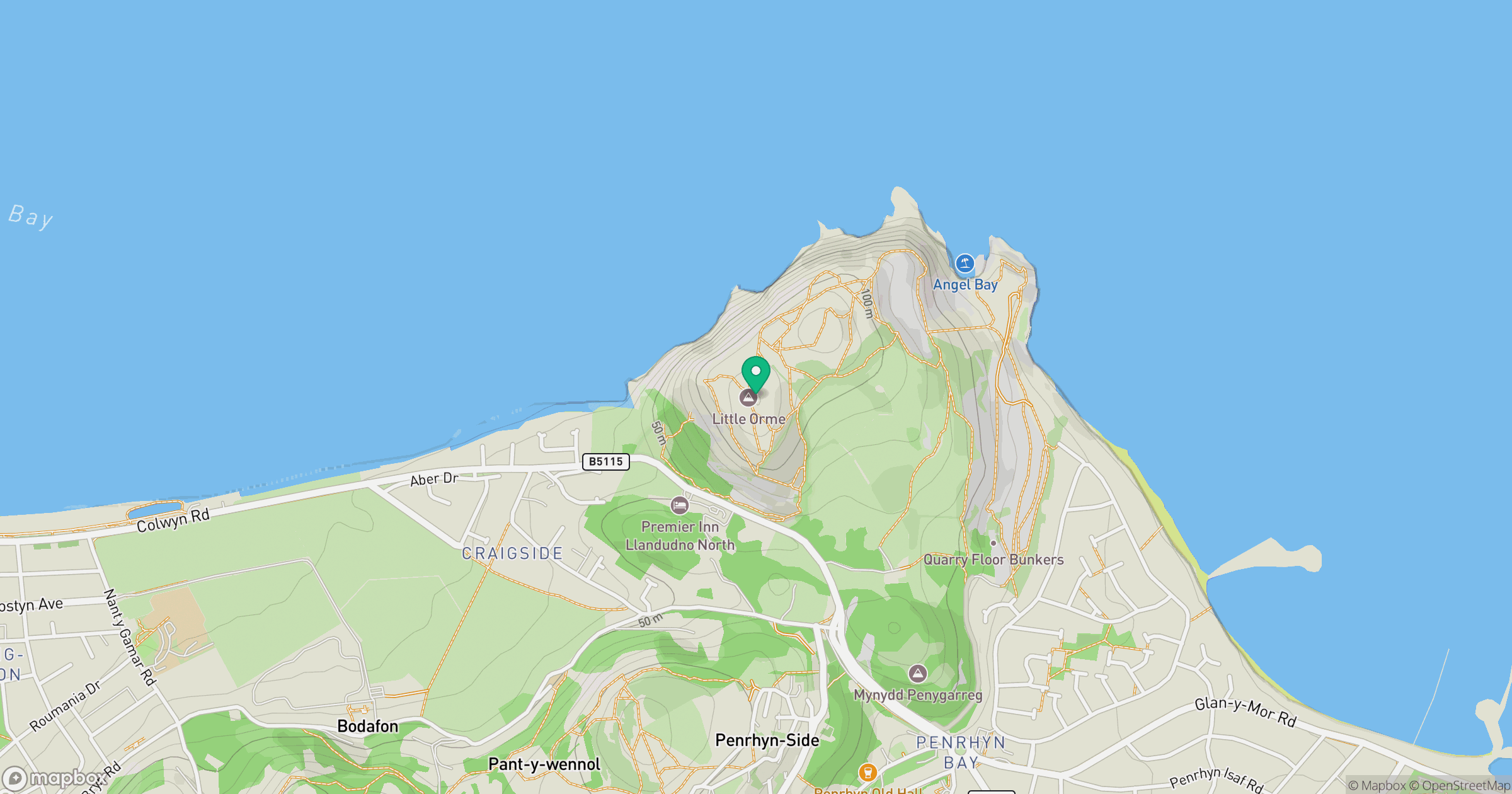
Grid reference: SH813823
View on OpenStreetMapOpens a map in a new tab, centred on the hill.
Nearby Hills
Great Orme [Y Gogarth]
207m
Carnedd Llewelyn
1,062m
Carnedd Dafydd
1,044m
Mynydd Tryfan
402m
Moel Siabod
872m
No comments yet. Be the first.